LocViewer java app free download

 Name - LocViewer
Category - travelnavigation
Resolution - multi
Type - jar
Size - 110 KB
Rating - 2/5 from 70 ratings
| Rate this app: | |
| 1023 downloads | |
Description:
Ver v1.6.2, for j2me
LocViewer loads map sections according to the current position from a Web service from the Internet and indicates the position on the display of the mobile phone.
LocViewer loads map sections according to the current position from a Web service from the Internet and indicates the position on the display of the mobile phone. As data source e.g. road maps or satellite photos can be selected. In addition the speed and the moving direction are indicated. The map sections can be panned and zoomed.
In order to reduce data traffic, the map sections are stored in the mobile phone. So a map section must be downloaded only once.
LocViewer runs on all phones which support at least CLDC 1.1 and MIDP 2.0 and allow access to Bluetooth (JSR 82) or the serial interface (data cable). That applies to nearly all current mobile phone models. Alternatively an integrated GPS receiver can be used if it can be accessed using JSR 179.
GPS receivers with Bluetooth or serial interface are supported, which provide the NMEA 0183 sentences GGA and VTG or RMC. That nearly all at the market available might be.
In the connection mode "Network/Internal" the Location API (JSR 179) is used. In this case no external GPS receiver is needed. In this case the location is determined by the GPS receiver or by the network provider. This functionality is obviously supported however in Germany so far by no provider.
Apart from the hardware, a free ESRI Global Account is the only prerequisite for the use of LocViewer. After the creation of your account, please don't forget to register for the ESRI ArcWeb Services?Public Services account in a second step.
Usage
- If applicable switch on GPRS.
- Start LocViewer.
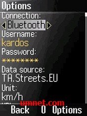
- In Menu "Options" enter user name and password of your ESRI account and change the desired connection mode if necessary. On Bluetooth capable mobile phones Bluetooth is preset, otherwise the data cable. In addition with selection of the data cable the Baud rate can be changed. The NMEA default value of 4800 Bit/s is preset. As data source for locations in Europe TA.Streets.EU is recommended. If needed, the automatic or manual altitude correction can be activated.
- To display the map section choose "Map". In the top the coordinates, the altitude, the speed, and the driving direction are indicated. The display can be switched to show UTM coordinates (Universal Transverse Mercator) or MGRS/UTMREF coordinates (Military Grid Reference System). In this case the Zone, Easting, and Northing are displayed. This information as well as the permanent position actualization can be switched off in the menu. The color of the cursor reflects the validity of the GPS data.
- The map section can be zoomed or panned with the Joystick or with the numerical keys. In this case the position actualization as well as the information indication are switched off automatically.
- The actualization of the position and the information indication can be switched on at any time in the menu again.
- The essential GPS data can be displayed by choosing "GPS data". One can switch between geographic, UTM, and MGRS/UTMREF coordinates using the menu.
- With the menu option "Maps" the map sections stored in the mobile phone can be displayed and if necessary deleted. In the map overview the map sections are listed with their numbers as well as minimum and maximum longitudes and latitudes. Individual map sections can be displayed simply by choosing them.
- In the menu "Options" the selected map sections can be deleted. Furthermore it is possible to delete ranges or all map sections. For the definition of the ranges to be deleted the data source, as well as longitude and latit

 Choose mobile
 Login
Login Signup


 Download directly on your phone by scanning this QR code