BaseNav java app free download

 Name - BaseNav
Category - travelnavigation
Resolution - multi
Type - jar
Size - 47 KB
Rating - 2/5 from 73 ratings
| Rate this app: | |
| 1923 downloads | |
Description:
S60v3 J2ME
Navigate
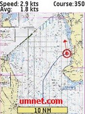
BaseNav Navigation is build for nautical navigation. It can also be used for biking and hiking.
The navigation software is written in java (J2ME). Your mobile device must support J2ME (with JSR 179).
A built in GPS or an external (Bluetooth) GPS receiver is necessary.
Use your own maps
The big difference with other (similar) software, is the fact that you can use your own maps. Scan your own (nautical) maps and calibrate them!
For more info see: User guide.
BaseNav Navigate options
The GPS / navigation software has the following options:
- Use your own maps
- Zoom in and out
- Toggle full screen
- Current speed
- Average speed
- Course
- Rose and arrow
- Tracking on device
- Google Maps tracking
How to use the software
Start the software and select continue (some devices ask you to accept). You will see the following information:
Long: The longitude which is used for reference
Lati: The latitude which is used for reference
Range: The safety range in meters
Long: The last longitude
Lati: The last latitude
Dist: The last distance between the reference and the last point
Max: The maximum distance found
When you see ??? the GPS is not ready
The main menu
You have two options:
- Unit (Now only metric)
- Safety range meters (default safety range)
Key functions:
- Key 1 - Reset the longitude / latitude reference point
- Key 2 - Reset the maximum distance found
- Key 4 - Decrease safety range
- Key 6 - Increase safety range
- Key 7 - Full screen
- Key 9 - Normal screen
Tips:
Start the application, increase the safety range (key 6). Wait for 15-30 minutes reset the longitude / latitude reference point (key 1), reset the maximum distance found (key 2) and decrease the safety range (key 4).
It will take some time before your GPS picks up all the satellites.

 Choose mobile
 Login
Login Signup


 Download directly on your phone by scanning this QR code